
Municipality of Poro
Poro is a fourth class municipality. According to the 2010 census, it has a population of 23,498.
Poro, along with the municipality of Tudela, is located on Poro Island of the Camotes Islands.
The patronal feast of Poro is celebrated on the third Friday of January, in honour of the Santo Niño de Cebu.
The town's name is derived from the Waray-Waray word puro meaning "island".
Aside from Visayan languages, Filipino, and English, the townsfolk also speak the local Porohanon language. Also known as Camotes Visayan, the language is mutually intelligible with other VIsayan languages
Porohanon is distinguished by the way the locals substitute sounds with e.g. the Cebuano Maayong buntag ("Good morning") is vocalised as Maazong buntag in Porohanon (possibly a handover from the yeísmo phenomenon in Spanish). Other dialectical variations include the Porohanon Ara dira instead of the standard Cebuano Na-a diha.
Poro comprises 17 barangays: Adela, Altavista, Cagcagan, Cansabusab, Daan Paz (formerly Poso), Eastern Poblacion, Esperanza, Libertad, Mabini, Mercedes, Pagsa, Paz (formerly Santa Rosa), Rizal, San Jose, Santa Rita, Teguis, Western Poblacion.
PORO, CAMOTES ISLAND ,
CEBU
Historical Background
The Municipality of Poro was founded on December 15, 1701 but was given recognition by the Spanish Colonial government only on January 16, 1780 through the efforts of Pedro Estrera who was named the first Capitan of Poro as recognition of his leadership. The name Poro came from the Waray word “puro”, meaning island. The early settlers of Poro came from Samar, and later, they were joined by others from Cebu, Bohol and Panay . During the Spanish period, Poro was already a thriving community overseen by Jesuit Mission posts in Palompon, Leyte . A survey made by the Spanish authorities under Capitan General Gomez Perez Dasmariñas in Manila on May 31, 1591 revealed that the whole of Camote ( Camotes Island ) and Mactan (Mactan) had 287 tributes with a population of 1,148 inhabitants. By this time, periodic raids from marauding slave traders had become the constant threat to the growing populace. The Alcalde mayor of Cebu thought that it was better for the natives to unify and defend themselves from the attacks. Poro at that time had two settlements: Maktang (now a sitio of Barangay Esperanza of Poro) and Tag-Anito (now the municipality of Tudela ). A conflict arose as to which settlement should become the seat of government. On the advise of Panganuron, an elder who lived on the banks of a river (now Barangay Libertad), the two settlements journeyed on foot towards each other at the break of day. They met on the site of what is now Poblacion, Poro, approximately eight kilometers from both settlements. On that day, inhabitants of the two settlements came to live together for the first time. They built a chapel on this site which later on was improved and became the parish church. The establishment of Poro brought about the creation of three more parishes in the Camotes Islands : Pilar (1859), San Francisco (1863) and Tudela (1898). The Philippine Commission Act 952 was enacted on October 22, 1902 reverting back Camotes Islands of Cebu Province . Earlier the Spanish government has annexed Poro and the rest of Camotes Islands to Leyte because of geographical proximity. Perhaps Camotes was seen as nearer Cebu City , the seat of the Cebu Government, than Leyte's set of government which is Tacloban City . Other events followed: five days after Camotes joined Cebu , Poro was annexed to Tudela, a former settlement of Poro. In 1909, it was re-established again as a municipality although the seat remained in Tudela until 1914 when the seat was transferred to Poro. Porohanons are descended from generations of seafarers who came and tamed the restless sea the sea that in turn defined and shaped their lives. In the early days when the dry “Habagat” wind battered its shores and when the nippy air of the “Amihan” turned up, the island isolated itself from its neighbors. All activity is suspended; trade from other ports and news from the mainland temporarily came to a stop. Thus, once in a while, they lived a life of seclusion, waiting for the unkind weather to recede. Life then meant a cycle of frequent squalls and tranquil intervals. A distinction that separates Porohanons from the rest of Camotes Islands is their sub dialect which is a combination of Cebuano, Waray, Boholano and Ilonggo. The patois is profusely spattered with the letter “z” and spoken with a thick accent. Dr. Resil Mojares, a Cebuano historian, said in an article that “at one point in time, the Camotes dialect was distinct from either Waray or Cebuano” until it evolved into a totally different sub dialect retaining older features which the Cebuano language has lost. Spoken alongside other dialects (like Cebuano, spoken by the other Camotes towns), and Tagalog (courtesy of television seta and tabloids), the Porohanon tongue is totally distinct and has survived through the years without any dilution at all.
PHYSICAL CHARACTERISTICS
A. Geographical Location
Poro is a fifth class municipality situated in Poro Island , one of the three islands comprising the Camotes Islands in Cebu Province . The municipality of Poro sprawls between 10 degrees 37' 30” to 10 degrees 43' 10” latitude and 124 degrees 23' 00” to 124 degrees 28' 50” longitude. It is bounded on the north by the strait of Kawit ; on the east by the municipality of Tudela ; on the south by the shark-infested Camotes Sea ; and on the west by the municipality of San Francisco . Travel time by fast craft from Cebu City is one (1) hour with two trips daily, 4 hours by a passenger-cargo vessel from Cebu City with one trip daily and two hours from Danao City by pumpboat with two trips per day. It is approximately 565 kilometers southeast of Manila , 62 kilometers northeast of Cebu City and 54 kilometers west of Leyte
.
B. Land Area
The municipality of Poro has a total land area of 6,388.7 hectares or 63.887 square kilometers. The timberland area is 736 hectares while 5650.7 hectares are classified as alienable and disposable land. C. Climate The municipality of Poro falls under the fourth type of climate. Rainfall is evenly distributed throughout the year. The most common air currents are the northeast monsoon, the trade winds and the southwest monsoon. The general direction of the winds are from the east to the southeast (February to April) and the southerly (May to September) D. Topography The municipality has mixed topographical reliefs. Areas around Barangay Mabini, Poblacion, Altavista and Libertad which cover a total land area of 2658.8 hectares or 38.82 percent of the total land area, have very steeply sloping lands in many directions to very mountainous to hilly areas. On the other hand, areas along the northern portion of the municipality, particularly Barangay Esperanza, have broad areas or nearly level lands and gently sloping areas with land sloping in one general direction. This slope category occupies an estimated land area of 3729.9 hectares or 54.46 percent of the total land area.
DEMOGRAPHY
A. Population Distribution
The National Statistics office in its September 1995 Census on Population and Housing, revealed that the municipality of Poro has a total population of 21,517. This gives an increase of 2,371 or 12.38% over the 1990 census which was 19,146. The estimated rate of increase is placed at 2.33% per annum. By 2008, the population is expected to reach 29,131. The high rate of increase which is almost equal to the national rate of 2.36% can be traced to the increasing economic activity in the municipality which has prevented those wishing to migrate to other places and those who came back from the other places and engage in business or other means of livelihood in the municipality.
ECONOMY
A. Agriculture 1. Crop Production The municipality of Poro is basically an agricultural economy. A total of 4,127 hectares or 60.26 percent of the total land area is devoted to agriculture. There are four major crops in the area, namely: rice, corn, coconut and fruits. Even the DENR declared timberland is planted to crops. 2. Livestock and Poultry Livestock-and poultry-raising is carried out mainly as a secondary livelihood of the people. Total backyard poultry production for 1996 was valued at P 1,190,700. Livestock (swine cattle, goat and carabao) production for the same year was P 46,802,000. 3. Fishery and Aquatic Resources Camotes Sea provides a good fishing ground for the residents of Poro. Improved fishing methods and mechanization have greatly increased the annual fish production of the marginal fishermen with the 1996 fish catch valued at 42,5M. 4. Forestry and Environment The DENR has classified a total of 738 hectares as timberland. However, this area is presently under cultivation and planted with coconut and root crops. A total of 722 hectares of the timberland area are considered as upland timberland and 16 hectares as lowland timberland. However, there are approximately 460 hectares of mangroves which is also declared as protected area. This area is located between Poro and San Francisco . If this area is added to the timberland area, the total would become 1,190 hectares. B. Commerce and Trade As of January 1997, the municipality has a total number of 500 sari-sari sores, 5 hardware, 1 gasoline station, 5 warehouses, 3 wholesalers, 30 carenderias, which are evenly distributed throughout the municipality. There is a fish market and a small public in the Poblacion, but no market day as is usually the practice in the rural areas. There is also a public market in Adela. C. Industry Light industrial establishments such as small scale ironworks, furniture making, concrete blocks making are operating in the area. Presently, there are 50 employees in the ironworks industry, 25 in furniture making and 58 in concrete block making. Likewise, there are 5 commercial corn miller located in Barangay Teguis, Cagcagan, Adela, San Jose and Daan Paz employing 25 people. Truck and jeep body building in Barangay Esperanza, Teguis and Mabini employ 25 people A group of women organized themselves and is now producing bags made from romblon and selling them to selected shops on Cebu City . There is also and egg producing association organized by a US Peace Corps Volunteer which supplies eggs to consumers in the town and in neighboring towns. A pearl culture company is also operating in the area with two pearl farms in Barangay Mercedes
D. Social Services and Community Development
1. Education As of June 1997, the municipality of Poro has a total of 6 primary schools, eleven elementary schools, four secondary schools and one college. In the primary level, Mactang has the highest enrollment with a total of 101 pupils, while Cansabusab has the least enrollment with a total of 30 pupils. 2. Health The municipality has no hospital but there is an emergency clinic where emergency operations are conducted especially for those who cannot afford the high cost in hospitals. The municipality is currently served by one Rural Health Doctor, one nurse, one Sanitary Inspector and eight midwives. Barangays Libertad, Esperanza, Mercedes, Cagcagan, Paz, Adela, San Jose and Daan Paz have health stations and one rural health center in the Poblacion where the Municipal Health Officer is holding office. There is no regular dentist to serve the dental needs of the residents. 3. Transportation Transportation facilities in the municipality are inadequate and inconvenient to commuters. Although there are already a number of jeepneys and other means of mass transport, there are no regular routes and trips to and from the Poblacion. The most common mode of transportation is by motorcycle. Transportation to Cebu City is regular and very comfortable. A fast craft plies the Cebu City – Poro route twice a day, one in the morning and another in the afternoon. Cargo-passenger vessels also ply this route everyday with RORO vessel scheduled every Monday. There also three trips per day to Danao City by pump boats. Ormoc City is also accessed by two pump boats daily. The municipality's road network consist of the provincial road, municipal road and barangay road with a total length of 105.5 kms. Road width averages 6 meters wide which consequently does not meet the standard. 4. Water Water resource in the municipality is mainly derived from the municipal water system. The barangays served by this system are Mabini, Eastern and Western Poblacion, Teguis, Pagsa, Mercedes, Esperanza, Cagcagan, Adela, Paz, San Jose , Daan Paz and Rizal. A water cooperative serves the water needs of Libertad. Others a served by deepwells and springs. 5. Power The Camotes electric Cooperative (CELCO) provides power services to the municipality. As of January 1998, 16 barangay are already energized out of a total of 17. Source: “ Cebu Comprehensive Land Use Plan” - HLURB
PORO, CAMOTES ---NAME OF LEADERS MAYORS
Spanish Period
Pedro Estrera.....................1796 --1800
Joaquin Estrera..................1800 --1804
Fermin Estrera...................1804 --1808
Marcelo Estrera.................1808 --1812
Agustin Culango................1812 --1820
Leon Garciano...................1820 --1824
Silverio Otadoy..................1824 --1828
Graciano Garciano.............1828 --1832
Demetrio Rojas..................1832 --1836
Timoteo Rojas....................1836 --1840
Agustin Gorgonio..............1840 --1848
Pedro Gonzales..................1848 --1854
Luis Gonzales....................1854 --1857
Custodio Otadoy................1857 --1860
Pablo Gutierez...................1860 --1863
Lucio Gonzales..................1863 --1866
Pedro Gonzales..................1866 --1869
Domingo Huete..................1869 --1871
Teodoro Gorgonio..............1871 --1872
Marciano Garciano............1872 --1874
Mariano Gorgonio.............1874 --1877
Trinidad Dondoyano.........1877 --1879
Eduvigio Garciano............1879 --1881
Vicente Otadoy..................1881 --1884
Felipe Sotto.......................1884 --1886
Felipe Martinez.................1886 --1887
Calixto Gonzales...............1887 --1889
Simeon Gonzales...............1889 --1891
Felipe Sotto.............. .........1891 --1893
American Period
Pres. Mun. Basilio Gonzales........1902 --1905
Pres. Mun. Elias Gonzales...........1906 --1908
Pres. Mun. Nicolas Otadoy..........1908 --1910
Pres. Mun. Fidel Martinez...........1910 --1914
Maximo Garciano........................1914 --1916
Serapion Martinez........................1916 --1922
Pablo Garciano.............................1922 --1928
Juan V. Muaña..............................1928 --1932
Felomino Sosmeña.......................1932 --1934
Honorato Garciano.......................1934 --1936
Felix Soscano...............................1936 --1937
Commonwealth Government
Alcalde Mayor Teofisto Otadoy....1938 --1941
Ramon Labayan............................1941 --1947
Ruperto Gonzales..........................1947 --1951
Mun. Mayor Moises Otadoy.........1951 --1967
Mun. Mayor Tiburcio Donaire......1967 --1977
Mun. Mayor Maximino Abejo......1977 --1979
Mun. Mayor Clarito Gonzales.......1979 --1986
Mun. Mayor Moises Otadoy..........1986 --1992
Mun. Mayor Dr. Isaar D. Rama.....1992 --2001
Mun. Mayor Edgar G. Rama..........2001 --2010
Mun. Mayor Luciano D. Rama Jr...2010 --Present


Municipality of Poro


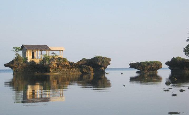
 Buho Rock is a coral rock shaped like a small ship docked at a port in one of the cliffs of the Western Poblacion in Poro. It is situated in one of the few public beach resorts on the island.It is a great place to be as a viewing deck to explore the turquoise waters of Camotes’ ocean with your naked eyes.For you to really enjoy your stay on this particular site cottages have been built with native-style roofs and open sides, and sits and tables are available, of course.
For you to exercise a little bit, you need to walk a steep flight of winding stairs to reach the ship-like structure. Some visitors also enjoy not just searching the horizon from Buho’s viewing deck…
They also snorkel, swim, and even dive from that structure then swim back to the nearby shore and climb up the stairs.Being not a private establishment, Buho Rock allows visitors to bring in their food or snacks to enjoy better the view.
 |
| Cliff in sitio Kanlambo, brgy. Paz (Santa Rosa) Poro, Camotes |
 |
| Langgue-langgue shrub found in Camotes island, Philippines |

A centuries old tree on the cliff

A centuries old tree on the cliff

Santa Rosa Beach in brgy. Paz, Poro, Camotes
 |
| Kalatsutsi Tree on the seashore cliff in Santa Rosa, Poro, Camotes, Philippines |

“The Church of Poro, the oldest in Camotes Islands, is dedicated to the Sto. Niño. The town was founded in 1737 and the parish was established in 1849. The church’s original belfry was destroyed and a new one was built in 1960’s” - Poro


 |
| Maktang Beach, Esperanza |
 |
| Maktang Beach, Esperanza |


 |
| Brgy. Esperanza |
 |
| Maktang, Esperanza |
CEBU
BACK TO CAMOTES ISLANDS
No comments:
Post a Comment