
Back to Main Page
Mount Mayon - Mayon volcano

The Philippines' most active volcano spewed fountains of red-hot lava and massive ash plumes anew Tuesday Jan. 23, 2018 in a dazzling but increasingly dangerous eruption that has sent more than 56,000 villagers fleeing to evacuation centers.
Lava fountains gushed up 700 meters (2,300 feet) above Mount Mayon's crater and ash plumes rose up to 3 kilometers (1.9 miles) Monday night.
Delicate Arch

Delicate Arch is one of the most famous arch formations in the country, and the trail to it is one of the most popular routes in Arches National Park. The Arch is on Utah license plates and is one of the most enduring symbols of the American West
Coron, Palawan, Philippines


Coron Island. Coron is the third-largest island in the Calamian Islands in northern Palawan in the Philippines. The island is part of the larger municipality of the same name. It is about 170 nautical miles (310 km) southwest of Manila and is known for several Japanese shipwrecks of World War II vintage.
Autumn Trees

The amount and brilliance of the colors that develop in any particular autumn season are related to weather conditions that occur before and during the time the chlorophyll in the leaves is dwindling. Temperature and moisture are the main influences.
A succession of warm, sunny days and cool, crisp but not freezing nights seems to bring about the most spectacular color displays. During these days, lots of sugars are produced in the leaf but the cool nights and the gradual closing of veins going into the leaf prevent these sugars from moving out. These conditions-lots of sugar and lots of light-spur production of the brilliant anthocyanin pigments, which tint reds, purples, and crimson. Because carotenoids are always present in leaves, the yellow and gold colors remain fairly constant from year to year.
The amount of moisture in the soil also affects autumn colors. Like the weather, soil moisture varies greatly from year to year. The countless combinations of these two highly variable factors assure that no two autumns can be exactly alike. A late spring, or a severe summer drought, can delay the onset of fall color by a few weeks. A warm period during fall will also lower the intensity of autumn colors. A warm wet spring, favorable summer weather, and warm sunny fall days with cool nights should produce the most brilliant autumn colors.
Kanlaon Volcano. Philippines

Known as a lenticular cloud, it is usually formed on the downwind side of a mountain when stable, moist air flows over a mountain, creating a series of lens or smooth saucer-shaped clouds, often mistaken for unidentified flying objects (UFOs).
South Beaches, Bermuda

St. Barths Island

British Virgin Island

St. John’s Trunk Bay

With its shallow, turquoise water and soft sand, St. John’s Trunk Bay is often counted among the finest beaches in the world. Explore the diverse marine life with a snorkeling expedition along the Underwater Trail through a coral reef.
St. Lucia, Caribbean

St. Lucia’s Pitons, two mountainous volcano spires on the southern end of the island. Covered in lush rainforest and luxurious resorts, the Caribbean country is a popular honeymoon spot.
Boracay, Philippines

White Beach is Boracay’s main draw, with powdery white sand and shallow azure water ideal for swimming and snorkeling.

White Beach is Boracay’s main draw, with powdery white sand and shallow azure water ideal for swimming and snorkeling.
Yosemite Falls

Part of North America's tallest waterfall, Lower Yosemite Fall is the final 320-foot (98-meter) drop. Deafening in spring and early summer when the waterfall peaks in volume, you can expect to get sprayed with water when standing on the footbridge near its base. This short, easy walk rewards with spectacular views of both Upper and Lower Yosemite Falls. This paved loop trail offers different vantage points of Yosemite Falls and Yosemite Creek, and you can stop at the many exhibits to learn more about the natural and cultural history of the area.
Mount Shuksan

Mount Shuksan is a glaciated massif in the North Cascades National Park. Shuksan rises in Whatcom County, Washington immediately to the east of Mount Baker, and 11.6 miles (18.7 km) south of the Canadian border. The mountain's name Shuksan is derived from the Lummi word [šéqsən], said to mean "high peak".The highest point on the mountain is a three sided peak known as Summit Pyramid. There are two named subsidiary peaks: Nooksack Tower and The Hourglass.
The mountain is composed of Shuksan greenschist, oceanic basalt that was metamorphosed when the Easton terrane collided with the west coast of North America, approximately 120 million years ago. The mountain is an eroded remnant of a thrust plate formed by the Easton collision.
Mount Shuksan may be one of the most photographed mountains in the Cascade Range. Photographs with its reflection in Picture Lake near Mount Baker Ski Area are particularly common. The Mount Baker Highway, State Route 542, is kept open during the winter to support the ski area; in late summer, the road to Artist Point allows visitors to travel a few miles higher for a closer view of the peak.
Olbrich Botanical Gardens

Olbrich Botanical Gardens is located in Madison, Wisconsin. Named for its founder, Michael Olbrich, the gardens are owned and operated jointly by the City of Madison Parks and the non-profit Olbrich Botanical Society. The gardens were established in 1952.
Noteworthy additions to the gardens were the Bolz Conservatory in 1991, and a Thai pavilion or sala, a gift to the University of Wisconsin–Madison from the Thai Chapter of the Wisconsin Alumni Association and the government of Thailand through its king, Bhumibol Adulyadej. Opened in 2002, it is one of only four sala outside of Thailand and one of two in the United States (the other is located in Hawaii).
Nyong River


The mountain is composed of Shuksan greenschist, oceanic basalt that was metamorphosed when the Easton terrane collided with the west coast of North America, approximately 120 million years ago. The mountain is an eroded remnant of a thrust plate formed by the Easton collision.
Mount Shuksan may be one of the most photographed mountains in the Cascade Range. Photographs with its reflection in Picture Lake near Mount Baker Ski Area are particularly common. The Mount Baker Highway, State Route 542, is kept open during the winter to support the ski area; in late summer, the road to Artist Point allows visitors to travel a few miles higher for a closer view of the peak.
Olbrich Botanical Gardens

Noteworthy additions to the gardens were the Bolz Conservatory in 1991, and a Thai pavilion or sala, a gift to the University of Wisconsin–Madison from the Thai Chapter of the Wisconsin Alumni Association and the government of Thailand through its king, Bhumibol Adulyadej. Opened in 2002, it is one of only four sala outside of Thailand and one of two in the United States (the other is located in Hawaii).
Nyong River

The Nyong is a river in Cameroon. The river flows approximately 640 kilometres (400 mi) to empty into the Gulf of Guinea.
The Nyong (formerly German: Yong) originates 40 km (25 mi) east of Abong Mbang, where the northern rain forest feeds it. The river's length is almost parallel to the lower reaches of the Sanaga River. Its mouth is in Petit Batanga, 60 km (40 mi) south-southwest of Edéa. In two places, Mbalmayo and Déhané, the river has huge rapids. The first 300 km (200 mi) of the river, between Abong Mbang and Mbalmayo, are navigable for small boats from April to November.
Jannah Paradise

Jannah, an eternal place for Muslim people, is the Islamic conception of paradise. The Arabic word Jannah is a shortened version meaning simply "Garden". According to Islamic eschatology, after death, one will reside in the grave until the appointed resurrection on Yawm al-Qiyāmah. Muslims believe that the treatment of the individual in the life of the grave will be according to his or her deeds in the worldly life. Jannah is often compared to Christian concepts of Heaven. According to Muslim belief, everything one longs for in this world will be there in Paradise. The highest level of Paradise is Firdaws, which is where the prophets, the martyrs, and the most truthful and pious people will dwell. In contrast to Jannah, the words Jahannam and Nār are used to refer to the concept of hell. There are many words in the Arabic language for both Heaven and Hell and those words also appear in the Qur'an and Hadith. Most of them have become part of the Islamic traditions.
Piva Lake

The Piva (Bosnian: Piva, Serbian Cyrillic: is a river in Montenegro and Bosnia and Herzegovina, shorter headwater of the Drina river, which it forms with the Tara river on the border with Bosnia and Herzegovina.
One of the water sources of Piva river is Durmitor’s river Komarnica, which is placed on the south side, while on the west side of Piva river are placed high Golija (1942 m), Bioc (2397 m) and Maglic (2388 m) mountains. From its source Sinjac it used to flow 33 km towards north untill Scepan Polje. There Piva's waters meet with those of Tara to create Drina river. Between 1967-1975 huge 220 m high dam was build 10 km upstream from Scepan Polje and spectacular 180 m deep Pivsko Jezero lake was born. That dam blocked the nature flow of Piva lake and present a big destruction of the nature's beauty.


One of the water sources of Piva river is Durmitor’s river Komarnica, which is placed on the south side, while on the west side of Piva river are placed high Golija (1942 m), Bioc (2397 m) and Maglic (2388 m) mountains. From its source Sinjac it used to flow 33 km towards north untill Scepan Polje. There Piva's waters meet with those of Tara to create Drina river. Between 1967-1975 huge 220 m high dam was build 10 km upstream from Scepan Polje and spectacular 180 m deep Pivsko Jezero lake was born. That dam blocked the nature flow of Piva lake and present a big destruction of the nature's beauty.


 |
| Some mysterious clouds looking like fingers appeared in the sky of Denmark on December 1, 2015. |
 |
| Snake Islet in Lake Danao, Pacijan island in Camotes Islands |


The leading edge of an Arcus Shelf Cloud formation inbound from the west in Sydney's south......... Oct. 14, 2014


Sunset is a unique miracle of nature that we are able to honor every single night. It is the westernmost city of Croatia, and the municipality includes Savudrija/Salvore, the westernmost point of Croatia.,,,,,,,,,
UMAG SUNSET......
UMAG SUNSET......


Sunset at the lake in the Abacoa Golf Course in Jupiter, Florida with Palm Tree.

Herbaceous plants , with a dynamic aspect of constant change , manifested in different seasons , plus a rich wildlife is incorporated , such as birds and butterflies, which enrich the composition of nature.

Full Moonrise on the Sea

Palm Trees And Tropical Resort, Bora Bora, French Polynesia

Kilauea Volcano in Hawaii

Sunset Surf in Hawaii Beach

Tchibo Rock

Machu Picchu
 |

 |
Antelope Canyon |


 |
| Horseshoe Bend is a horseshoe-shaped meander of the Colorado River located near the town of Page, Arizona, in the United States. |
 |
Chasm Lake- Colorado, USA |


 |
| Medicine Lake is located within Jasper National Park, Alberta, Canada. It is located approximately 20 km southeast of the townsite of Jasper, |
 |
| Skaftafell National Park, Iceland, Polar Regions |
 |
| Lake Solitude is a lake located in Grand Teton National Park, in the U.S. state of Wyoming. |
 |
| Yosemite Valley is a glacial valley in Yosemite National Park in the western Sierra Nevada mountains of Northern California |
 |
| Ghizer District is the westernmost part of the Gilgit-Baltistan region of Pakistan. Its capital is Gakuch. Ghizer is crossroads between Gilgit and Chitral and also to China |
 |
Sunset Mount Rainier National Park - USA |
 |
|
 |
Lonely island in Sweden, Stockholm Archipelago |
 |
| Hvítserkur is a 15 m high basalt stack along the eastern shore of the Vatnsnes peninsula, innorthwest Iceland. |
Green Roof -Quindio Colombia

A green Roof is a roof of a building that is partially or completely covered with vegetation and a growing medium, planted over a waterproofing membrane. It may also include additional layers such as a root barrier and drainage and irrigation systems. Green roofs serve several purposes for a building, such as absorbing rainwater, providing insulation, creating a habitat for wildlife.
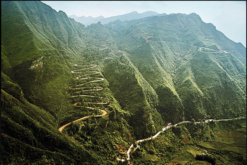
Winding Road
Jungle in Brazil


Kronotsky (Russian: Кроноцкая сопка, Kronotskaya Sopka) is a major stratovolcano of the Kamchatka Peninsula, Russia. It has a particularly symmetrical conical shape, comparable to Mount Fuji in Japan and to Mayon Volcano in the Philippines. The summit crater is plugged by a volcanic neck, and the summit itself is ice capped. It exhibits the classic radial drainage pattern, extending downward from its crater. Kronotsky is considered to be one of the most scenic volcanos in Kamchatka.
Klyuchevskaya Sopka

Klyuchevskaya Sopka (Russian: Ключевская сопка; also known as Kliuchevskoi, Russian: Ключевской) is a stratovolcano, the highest mountain on the Kamchatka Peninsula of Russia and the highest active volcano of Eurasia. Its steep, symmetrical cone towers about 100 kilometres (60 mi) from the Bering Sea. The volcano is part of the natural Volcanoes of Kamchatka UNESCO World Heritage Site.
Klyuchevskaya's first recorded eruption occurred in 1697, and it has been almost continuously active ever since, as have many of its neighboring volcanoes. It was first climbed in 1788 by Daniel Gauss and two other members of the Billings Expedition. No other ascents were recorded until 1931, when several climbers were killed by flying lava on the descent. As similar dangers still exist today, few ascents are made.
Klyuchevskaya Sopka is considered sacred by some indigenous peoples, being viewed by them as the location at which the world was created. Other volcanoes in the region are seen with similar spiritual significance, but Klyuchevskaya Sopka is the most sacred of these.
Mount Mayon

Mount Mayon, is an active volcano in the province of Albay, on the island of Luzon in the
Philippines. Renowned as the "perfect cone" because of its almost symmetric conical shape, the mountain was declared a national park and a protected landscape on July 20, 1938, the first in the country. It was reclassified a Natural Park and renamed Mayon Volcano Natural Park in the year 2000.
Maelifeell Volcano

In the south of the island, this volcanic cone made up of ashes and projections of solidified lava was created by one of the numerous eruptions that occurred beneath the ice of the Myrdalsjökull glacier. The Maelifell volcano emerged from the retreating glacier about 10.000 years ago at the end of the last Ice Age and is now bathed by the torrents flowing from the melting glacier. Its perfect cone which stands 656 feet (200 meters) above the plain is covered with grimmia, a moss that grows on lava that has cooled down and changes color, from silvery grey to bright green, depending on the soil’s humidity. This moss is one of the few plants that have been able to grow on Iceland’s territory. It is indeed characterized by a certain botanical poverty with less than 1.300 vegetal species (including 500 species of moss). Only 40 percent of land is covered with permanent vegetation. Iceland (it name says it all, “the land of ice”) is geologically very young at only 23 million years old. It has over 200 active volcanoes and many glaciers that cover almost an eighth of the island’s surface area.
Mount Shishaldin

Mount Shishaldin is a moderately active volcano on Unimak Island in the Aleutian Islands chain of Alaska. It is the highest mountain peak of the Aleutian Islands. The most symmetrical cone-shaped glacier-clad large mountain on earth, the volcano's topographic contour lines are nearly perfect circles above 6,500 feet (2,000 m). The lower north and south slopes are somewhat steeper than the lower eastern and western slopes. The volcano is the westernmost of three large stratovolcanoes along an east–west line in the eastern half of Unimak Island. The Aleuts named the volcano Sisquk, meaning "mountain which points the way when I am lost." The upper 2,000 meters is almost entirely covered by glacial snow and ice. In all, Shishaldin's glacial shield covers about 35 square miles (91 km2). It is flanked to the northwest by 24 monogenetic parasitic cones, an area blanketed by massive lava flows. The Shishaldin cone is less than 10,000 years old and is constructed on a glacially eroded remnant of an ancestral soma and shield. Remnants of the older ancestral volcano are exposed on the west and northeast sides at 1,500–1,800 meters elevation. The Shishaldin edifice contains about 300 cubic kilometers of material. A very steady steam plume rises from its small summit crater which is about 500 feet (150 m) across and slightly breached along the north rim.
Mount Fuji

Kamchatka

It juts into the Pacific Ocean and has about 330,000 inhabitants. This peninsula is filled with volcanoes, part of which is inscribed on the World Heritage List of UNESCO since 1996. Kamchatka is surrounded by the Sea of Okhotsk to the west, the Bering Sea and Pacific Ocean to the east. The peninsula has a high seismic activity, it is located on a subduction zone between the Pacific Plate and the Eurasian plate. His two volcanic mountain ranges are part of the Pacific Ring of Fire where we find the greatest concentration of active volcanoes. The 1952 earthquake reached a magnitude of 9. Nearby there are the trench of the Kuril Islands, the third deepest pit of the world, it reached a depth of 10,542 meters. The great peninsula of Kamchatka is a land of young Geologically, the peninsula has advanced to the ocean there are about a million years.
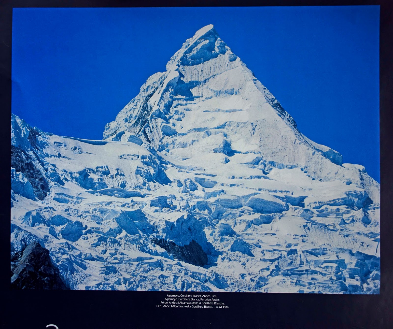
Mount Quitaraju
Mount Egmont
 |
Mount.Egmont (Mount Taranaki), Egmont National Park, Taranaki, North Island, New Zealand, |
 |
| New Zealand Sunrise Scenery and Nature Landscape |
 |
| Lake Pukaki, Sky Clouds, Mountains Nature and Scenery New Zealand South Island |

Tree on the edge of a cliff in Camotes island Phil.

No comments:
Post a Comment