Thursday, March 31, 2016

City Hall in the Philippines


Alaminos city hall
Angeles city hall
Antipolo city hall
Bacolod city hall
Bacoor city hall
Bago city hall
Baguio city hall
Bais city hall
Balanga city hall
Batac city hall
Batangas city hall
Bayawan city hall
Baybay city hall
Bayugan city hall
Binan city hall
Bislig city hall
Bogo city hall
Borongan city hall
Butuan city hall
Cabanatuan city hall
Cabuyao city hall
Cadiz city hall
Cabadbaran city hall
Cagayan de Oro city hall
Calamba city hall
Calapan city hall
Calbayog city hall
Caloocan city hall
Candon city hall
Canlaon city hall
Carcar city hall
Catbalogan city hall
Cauayan city hall
Cavite city hall
Cebu city hall
Cotabato city hall
Dagupan city hall
Danao city hall
Dapitan city hall
Dasmariñas city hall
Davao city hall
Digos city hall
Dipolog city hall
Dumaguete city hall
Escalante city hall
https://porocamotes.blogspot.com/2018/08/back-to-main-page-city-history-city-of.html
Gapan city hall
General Santos city hall
Gingoog city hall
Guihulngan city hall
Himamaylan city hall
Ilagan city hall
Iloilo city hall
Iligan city hall
Isabela city hall
Kabankalan city hall
Kidapawan city hall
Koronadal city hall
Lamitan city hall
La Carlota city hall
Laoag  city hall
Lapu-Lapu city hall
Las Piñas city hall
Legaspi city hall
Ligao city hall
Lipa city hall
Lucena city hall
Maasin city hall
Mabalacat city hall
Malaybalay city hall
Makati city
Malolos city hall
Mandaloyong city hall
Mandaue city hall
Malabon city hall
Manila city hall
Marawi city
Marikina city hall
Masbate city hall
Mati city hall
Meycauayan city hall
Muños city hall
Muntinlupa city hall
Naga city hall, Camarines Sur
Naga city  hall,  Cebu
Navotas city hall
Olongapo city hall
Ormoc city hall
Oroquieta city hall
Ozamis city hall
Pagadian city hall
Palayan city hall
Passi city hall
Puerto Princesa city hall
Pasig city hall
Parañaque city hall
Pasay city hall
Quezon city hall
Roxas city hall
Sagay city hall
Samal island  garden
San Carlos city hall- Pangasinan
San Carlos city- Negros
San Fernando city Pampanga
San Fernando city-La Onion
San Jose city-Nueva Ecija
San Jose city- Del Monte
San  Juan city hall
San Pablo city hall Laguna
San Pedro city -Laguna
Santa Rosa city hall-Laguna
Santiago city hall -Isabela

Silay city hall
Sorsogon city hall
Sipalay city hall
Surigao city hall
Tabaco city hall
Tabuk city hall
Tacloban city hall
Tacurong city hall
Tagaytay city hall
Tagbilaran city hall
Taguig city hall
Tagum city hall
Talisay city hall Cebu
Talisay city hall Negros
Tanauan city hall
Tandag city hall Surigao
Tangub city hall
Tanjay city hall
Tarlac city hall
Tayabas city hall
Toledo city hall
Tuguegarao city hall
Urdaneta city hall
Valenzuela city hall
Victorias city hall
Vigan city hall- Ilocos
Zamboanga city hall

Thursday, March 10, 2016

Escalante, Negros Occidental

Escalante, officially City of Escalante, is a fourth-class component city in the province of Negros Occidental, Philippines. According to the 2015 census, it has a population of 94,070 people.

HISTORY


Pre-Spanish Era

Virtually nothing is known of Escalante during the pre-Hispanic era. But archaeological findings in October 1975 and May 1976 made by a team of Anthropology students led by Professor Lionel Chiong of Silliman University reveal an early record of men who inhabited not only the present city but also the island of Negros during the pre-Spanish time. The findings were recovered in nine (9) graves in what seemed to be an ancient burial ground in Brgy. Japitan, a coastal barangay lying along the Tañon Strait, facing the island of Cebu, some 17 kilometers from the city proper. The artifacts consisted of celadon plate and bowls, stoneware bowls and jars, a Sung Dynasty (960-1280 A.D.) jarlet, gold beads, iron implements, daggers and a hunting knife with an ivory bone handle.

Obviously buried with the dead, the plate, bowls, jars and iron implements were found alongside the skeletal remains, the daggers and hunting knives on top of the breast section and the gold beads inside the skulls in-between the upper and lower jaws. When carbon-14 tested, these findings together with the human skeletal remains were found to date as far back as the 12th century A.D. All this proved that present-day Escalante was inhabited by settlers with a relatively developed culture who were engaged in some form of trade and commerce with the outside world, such as the Chinese and Japanese traders who could have brought the jarlet, stoneware and celadon pieces during the Ages of Contacts and Trade with the East (11th & 12th centuries A.D.)

Spanish Era

The northeastern part of Negros Island was "one of the most cultivated regions" in the mid-19th century.

On November 28, 1856, Governor-General Manuel Crespo issued a decree creating the towns of Escalante and Saravia. The decree ordered "that the two towns in question would be separated immediately from their mother town, Silay," although the spiritual separation of the two "would await the building of churches and convents in Saravia and Escalante." The latter had its seat of government in the barrio of Nueva Sevilla (Brgy. Old Poblacion).

The Parish of Escalante was finally established on May 22, 1860 with Fr. Cipriano Navarro, OAR, as the first Parish Priest. Fr. Navarro, in a report to the Recollect Provincial in 1861, wrote that the inhabitants of his Parish and its 14 barrios lying along the northeast portion of the island from Calatrava to Himogaan, "speak the Cebuano dialect and all, or the majority, came from Cebu, with the exception of those from Barrio Marianas (Himogaan) . . . who came from the district of Iloilo and speak the Hiligaynon dialect."


In 1859, a politico-Military Command was established in Bacolod under Governor Emilio E. Saravia with six towns under its jurisdiction: Escalante, Guihulngan, Jinuboan, Jimalalud, Tayasan, and Ayungon.Two more were added, Arguelles (Sagay) and Calatrava when these were created into separate towns on July 3, 1863. This ended with the division of Negros into two provinces in 1889.

Schools for boys and girls were established in the late 1860s. By 1869 a school for boys and another for girls were already operating in the town. By 1890, these schools were among the very few managed by Normal School graduates.

As early as 1871, Escalante was a major link between Bacolod and Cebu. A mail service route, Bacolod-Escalante-Tutuban-Toledo, Cebu was already exclusively in use by May 1871. In 1875 a mail boat belonging to Emerenciano Amante, the Gobernadorcillo (Mayor) of Escalante, transported mail between Toledo and Escalante every week.

A telegraphic station was established in 1894. The telegraphic cable was extended later on to Tuburan, Cebu and was operational by October 1897.

The inhabitants of the town lived from subsistence agriculture. They produced among others, rice, corn, buri, edible root crops, and tobacco. Their second most important economic activity was fishing.

Tobacco was grown commercially but its production decreased when monopoly was established starting from the time of Don Emilio Saravia (1855–1857), the first politico-military of the Negros Island. In its stead, sugarcane was gradually being grown. It was not clear when the first sugar mill was established in town. But by 1891, Escalante had already 6 steam-engine sugar mills; 36 powered by horses; and 11 by carabaos. Approximately 848 hectares were planted to sugarcane..

American Era

The American period covering some 45 years (December, 1898 to July 3, 1946, except for a few years under the Japanese occupation) saw marked changes in the socio-cultural, economic and political complexion of the area and its people. To capture the hearts and minds of the inhabitants without the use of guns and cannons, the Americans opened the first free elementary school at Old Poblacion in the early 1900s.

A Gabaldon-type elementary school building was constructed at Old Poblacion during the term of Mayor Fernando Lucot (1912–1918). The municipal hall and the town plaza were constructed and developed during the time of Francisco Ferrer, Sr. Also at this time, the first municipal school site where the first elementary school was located, was formally acquired, and the installation of the Rizal Monument at the public plaza completed. The municipal portal and Rizal Monument was built on Sept. 15, 1955. The bandstand and skating rink was constructed on September 28, 1935.

Japanese Era

In 1942, the occupation by the Japanese Imperial forces entered the towns in Escalante. The establishment of the general headquarters of the Philippine Commonwealth Army was active on January 3, 1942 to June 30, 1946 and the 7th Infantry Regiment of the Philippine Constabulary was active again on October 28, 1944 to June 30, 1946 and military stationed in the town municipality of Escalante during the Japanese Occupation.

In 1945, local Filipino soldiers of the 7th, 71st, 72nd, 75th and 76th Infantry Division of the Philippine Commonwealth Army and the 7th Infantry Regiment of the Philippine Constabulary was liberated the towns in Escalante, Negros Occidental and helping Negrosanon guerrilla fighters defeats and attacking Japanese Imperial forces and ended of the Second World War.

In 1941, Victor Bedonia succeeded Francisco Ferrer Sr. as mayor, and was supported by the local guerillas. The siege of all Filipino troops of the Philippine Army and Constabulary units was found liberated in the town municipality on 1945 against the Japanese. He served until 1948. The Japanese however installed Enrique Ballesteros as mayor until the end of the war.

Post War Era

Two (2) years after liberation, Escalante was divided into two (2) municipalities. President Elpidio Quirino issued Executive Order 141 dated May 19, 1948 "Organizing certain barrios of the Municipality of Escalante, Province of Negros Occidental, into an independent municipality under the name Toboso", to take effect July 1, 1948. Victor Bedonia who was then the incumbent mayor of Escalante opted to become the first mayor of the newly created town of Toboso. Pedro Benignos took over until 1950. In 1951, Evaristo Sanz took over and was replaced thereafter by Amando Tambo. It was during Mayor Tambo’s time when the seat of government, by virtue of Executive Order No. 301 issued by President Carlos P. Garcia on May 30, 1958, was transferred from Brgy. Old Poblacion to its present site at Brgy. Balintawak.

The first high school, the Escalante National High School, was donated by Manuel A. Lopez in 1946 and established in 1948. A decade later, in 1961, the Mount Carmel College was established by the Order of the Carmelites. Aside from the churches in the Municipality of Toboso, in Escalante and in Brgy Old. Poblacion, it also erected the Magdalen Hospital which was run by the Sisters of Julie Postel. This hospital is now called the Dr. Vicente Gustilo District Hospital, under the management of the Provincial Government. This placed the new town in an enviable position, not only being a center of higher education and quality medical care in this part of Negros.

This brought about profound changes in the socio-cultural, economic and political life of the town as it provided the much-needed opportunity for children of poor families in the area to acquire college education. Other public schools were opened up later on, such that there are now 27 public elementary schools, 6 national public high schools and 3 extension high schools.

Geography

Escalante has a total land area of 19,276.303 hectares (47,632.78 acres). It is located on the northeastern tip of Negros Occidental, facing the island of Cebu. It is 49 kilometres (30 mi) from San Carlos City and 95 kilometres (59 mi) from Bacolod City, the provincial capital. It is bounded on the north and west by the city of Sagay, on the south by the town of Toboso and on the east by the Tañon Strait.

Outside the city center of Escalante, there is a separate region of low rolling hills, especially going to its upland barangays towards Mt. Lunay. The hill land section is the remnant of past volcanism and probably, represents either dormant volcanic cinder cones or outliers of a once more extensive volcanic formation. Local residents in the upland barangays of Escalante at the foot of Mt. Lunay testify to period rumblings of a volcano generally believed 'to be dead'. An indicator of the dormant character of Mt. Lunay is the existence to this day of a sulphur spring at its foot. Often, the slopes of these hills as in Barangay Binaguiohan are quite steep. However, the steepness of the slope has not stopped Escalantehanons in cultivation of the hillside.

Coastal enviroment

The diversity of plants in the coastal environment of Escalante is one of the richest in Occidental Negros. Its coasts comprise two surviving ecosystems: the mangrove, consisting of trees and shurbs that occupies the landward portion of its coastal areas; the seagrass, or grasslike plants, that thrive on it shallow nearshore area. In a limited coastal zone, remnants of a third ecosystem, coral reef may be found but in residual, degraded form. The marine waters of Escalante are generally warm throughout the year, except for early mornings of the cool months of December, January and February. Salinity of its waters is within reasonable amount, at 28-36 parts per thousand.

Climate

The atmospheric conditions influencing the climate of Escalante as a whole are the same conditions operative in Negros Island. During the summer months (April to December) an air stream is directed from the south. This air current follows a counterclockwise path as it approaches the low-pressure center of the Asian continent, and reaches the Philippines from a southwestern direction as the southwestern monsoon or habagat. During the period from November to January, Negros has relatively cool weather as the Asian continent cools more rapidly than the surrounding seas, resulting in high-pressure centers leading to winds being deflected in a clockwise fashion.

This period is known as the northeastern monsoon or amihan. From March to April the northeastern wind system dominates. The cool season in Escalante is from December through March. It is also the time when low tides called aya-ay prevail, making beachcombing of its shores more pleasurable. The latter part of March through June is when the highest temperatures prevail. But being largely coastal, Escalante enjoys a constant flow of refreshing sea breeze.


Demographics

The city has grown at a respectably fast rate, averaging 1.63% in the ten years (2000 thru 2010). The May 2010 Census on Population showed that population increased to 93,005 persons. This means that on average that population grew by 1.63% annually since 2000. This is only about 3.20% of the province’s population which includes Bacolod City or 3.88% without it. At this rate, the city’s population is expected to double by year 2053.

The average household for 2000 was 4.89 persons per household, which is lower than the 5.0 national, 5.1 regional and the 5.24 provincial averages. NSO estimates there were 92,035 persons in 2007 in 18,644 households. This means, the average households size increased to 4.94.

As of December 2009, the average age is 24 years old.

Escalante has the highest population density (persons/square kilometer) in 2007, among the provinces's cities at 736.3, second only to the provincial capital, Bacolod City. The provincial average is 362.1, while the cities average 417.8.

Wednesday, March 09, 2016

Dumaguete city

Back to Main Page


Dumaguete City, is a component city in the Philippines. It is the capital of the province of Negros Oriental. Having a total of 131,377 inhabitants as of 2015 census, it is the most populous city in the province. The city is nicknamed The City of Gentle People.

Dumaguete is referred to as a university city because of the presence of four universities and a number of other colleges where students of the province converge to enroll for tertiary education. The city is also a popular educational destination for students of surrounding provinces and cities in Visayas and Mindanao. The city is best known for Silliman University, the country's first Protestant university and the first American university in Asia. There are also 18 public elementary schools and 8 public high schools. The city's student population is estimated at 30,000.

Dumaguete attracts a considerable number of foreign tourists, particularly Europeans, because of easy fast ferry access from Cebu City in Central Visayas, the availability of beach resorts and dive sites, the attraction of dolphin and whale watching in nearby Bais City. Dumaguete is listed 5th in Forbes Magazine's "7 Best Places to Retire Around the World".

The power source of the city comes from the geothermal power plant in Palinpinon, Valencia. The city has redundant fiber optic lines and is a focal point for telecommunications. It is the landing point for fiber optic cables linking it to Manila (the capital of the nation), the whole Visayas and cities south of Luzon, as well as to other cities north of Mindanao.


Etymology
"Dumaguete" was coined from the Cebuano word dagit, which means "to snatch". The word dumaguete, meaning "to swoop", was coined because of frequent raids by Moro pirates on this coastal community and its power to attract and keep visitors, both local and foreign. In 1572, Diego López Povedano indicated the place as Dananguet, but cartographer Pedro Murillo Velarde in 1734 already used present name of Dumaguete for the settlement.

Geography and climate
The city has a land area of 3,362 hectares (8,310 acres), situated on the plains of the southeastern coast of the island of Negros near the mouth of the Banica River. Of the province's 19 municipalities/towns and 6 cities, Dumaguete is the smallest in terms of land area. It is bounded on the north by the town of Sibulan, on the south by the town of Bacong and on the west by the town of Valencia.

As a coastal city, it is bounded on the east by the Bohol Sea and the Tañon Strait, serving as a natural border of Negros Oriental to the neighboring island provinces of Cebu, Bohol and Siquijor. The city's topography is generally flat from two to six kilometers from the shoreline. It slopes gently upwards to the adjoining municipality of Valencia. The highest ground elevation is located at the boundary of the municipality of Valencia, about one hundred meters above mean sea level. About 93% of the land have slopes of less than 3%. The remaining areas have 3% to 5% slope.

Demographics
As of the census in 2015, there are 131,377 people and 21,582 households residing in the city (as of 2010). The city has the least poverty incidence among urban centers in Visayas, according to the 2009 Small Area Estimates (SAE) of Poverty done by the National Statistical Coordination Board (NSCB). It has an average daylight population of 400,000 people. Dumaguete is the most populous city in Negros Oriental, comprising 9.05% of the province's total population. Its total voting population is 68,648 as of 2010.

Education
Dumaguete has earned the distinction of being known as the "center of learning in the South," or a university city due to the presence of universities that have made their mark nationally and abroad. The city is a melting pot of students, professionals, artists, scholars and the literati coming from different parts of the country and the world.

Silliman University is the dominant institution of higher learning in Dumaguete, providing the city with a distinct university town atmosphere. It is the first Protestant university in the country and the first American university in Asia. The 610,000 m² campus is adjacent to and intermixed with the city's downtown district. Some of its buildings have likewise been recognized as landmarks. These buildings include the Silliman Hall, Hibbard Hall, Katipunan Hall, the Luce Auditorium, and the Silliman Main Library (considered as one of the biggest libraries in the Philippines).

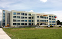
Other universities located in the city are: Foundation University (1949), a private non-sectarian university, its Main Campus where the site of a very popular Sofia Soller Sinco Hall dubbed as White House of Dumaguete is located at Meciano Road offers tertiary education programs while North Campus along Locsin Street is the home of Foundation Preparatory Academy for basic education programs. The Negros Oriental State University (NORSU) which was founded on 1907, has its two main campuses in the city, the Main Campus 1 is beside the Provincial Capitol building while Main Campus 2 is located in barangay Bajumpandan. It is the only state university in Negros Oriental and is very popular among students from different towns and cities of the province and some other parts of the country. St. Paul University Dumaguete (1904) is the first Saint Paul educational institution to be established in the Philippines by the Sisters of Saint Paul of Chartres (SPC) from France and considered as premier Catholic university of Dumaguete City.

Hotels and tourism
Data from the Department of Tourism show that Dumaguete and Negros Oriental are among the top ten most visited tourist destinations in the country. Tourists visit popular sites such as: the historic Rizal Boulevard aligned with some hotels, coffee shops, fine-dining restaurants and bars including the latest dining commercial complex, Paseo Perdices is the preferred location of Max's Restaurant, Yellow Cab Pizza and among others; Silliman Hall-home of University's Anthropology Museum; St. Catherine of Alexandria Cathedral being the oldest stone church of the island of Negros and ecclesiastical seat of the bishop of Roman Catholic Diocese of Dumaguete and Campanario de Dumaguete which is considered as one of the oldest heritage landmarks of Negros Island Region. Dumaguete serves as the main gateway to Negros Oriental.


Transportation

Air

Sibulan Airport (IATA: DGT, ICAO: RPVD), also known as Dumaguete Airport or Dumaguete-Sibulan Airport, is the city's domestic airport located in neighboring Sibulan town in the north. It provides daily flights to and from Manila, Cebu City and other Philippine cities through Cebu Pacific, Cebgo and PAL Express. However, a new airport is being planned to be built in Bacong, a town bordering Dumaguete in the south The proposal for the transfer and upgrading of this airport to international standards has already been approved and should be completed before 2025. An initial PHP 500 million budget has already been released for initial study and procurement of free lands.


Sea
Dumaguete, as a major port city is a jump-off point for passengers/tourists who are going to other Visayas and Mindanao areas. There are daily ferry connections to the islands of Cebu, Bohol, Siquijor and Mindanao operated by Archipelago Philippine Ferries Corporation (Fast Cat), Montenegro Lines, Ocean Jet Shipping, Cokaliong and other companies. Dumaguete is an access city for passengers/tourists going to Cebu which is dubbed as economic hub of the Visayas. There are smaller ports north of the city where short and frequent ferry connections are available to that island as an alternative. Dumaguete is a port of call for travelers to Manila and Zamboanga City by ship serviced by 2GO Travel.


Land
The main form of public transport in Dumaguete is the motorized tricycle. The Dumaguete version of the motorized tricycle can fit up to 6-8 passengers. For transport to destinations outside the city limit, there are jeepney and buses travelling set routes. Meanwhile, Vallacar Transit Corporation, the company that operates Ceres buses recently constructed a 2-storey terminal building in Dumaguete just beside the newly erected commercial center, the Marketplace.

Tuesday, March 08, 2016

Dipolog city

Dipolog city and the capital of the province of Zamboanga del Norte on the southern Philippine island of Mindanao. Geographically, the city is surrounded by rolling hills to the southeast and the Sulu Sea to the north.

Dipolog is known for its wild orchids and its sardine industry which stems from the rich fishing area off its shores. It is known as the "Gateway to Western Mindanao" through the Western Nautical Highway and has also been called the "Bottled Sardines Capital of the Philippines.

Dipolog can be reached by plane via Dipolog Airport or by ferry at the nearby Pulauan Port in Dapitan City. The construction of a roll-on/roll-off facility at Barangay Galas will allow for the eventual transfer of the service to Dipolog while retaining inter-island operations at Pulauan, which is soon to become a base port.

A popular city attraction is the foreshore Dipolog Boulevard which, though still in its second phase of construction, has become a popular haven for exercise and leisure. It is also the site for various celebrations and festivals in the city. In the third phase of the project, the length of the boulevard will be extended to reach the seaport in Barangay Galas.

Geography

Dipolog City is known to be as the "Gateway to Western Mindanao" it is situated in the Northwestern part of the Province of Zamboanga del Norte. It is bounded on the north by Dapitan City, on the east by the municipality of Polanco, on the south by the municipality of Katipunan and on the west.

Its land area in 1914 covered an approximate land area of 248,587 hectares under Act No. 302 of the Philippine Islands. It was substantially reduced in 1951 to the current 13,628 hectares, after two barrios of Dipolog were converted into Municipalities of Polanco, and Piñan under Executive Order of the President No. 467, dated August 22, 1951.

History

Spanish regime
Earliest recorded political history of Dipolog started in 1834 with the re-organization of Spanish Civil Government. At that time, Tulwanan's political territory was still part of the Municipality of Dapitan with Don Domingo Ruiz, a native, as its Capitan or town executive. Sometime that year, a Spanish Recollect Missionary arrived in Tulwanan looking for its barrio executive or local chieftain. Upon meeting a native, the Missionary asked; "Donde esta el Capitan?". The native understanding only the word "Capitan" pointed to the west and said in Subanen Di-pag, " meaning across the river. Guided by his Muchacho a Tagalog boy named Antonio Subido, the Friar proceeded down river and upon reaching the Boholano settlement named the place "Dipag".

Technically, Dipag and Tulwanan are two different settlements at that time with the former composed of Boholano natives and the latter mostly of Subanen ancestry. When the friar returned to Dapitan, he identified the location of the larger Boholano settlement as Dipag but was not officially written. Frequent conversations by the Spaniards pronounced it in Spanish accent Dipolog which was eventually adopted by the natives. The final political survey surprisingly added the letter 'L' written on it after officially becoming a barrio of Dapitan. From that time Tulwanan's political identity ceased to exist. By the 12th century the Subanen settlers had colonized most of what is now Zamboanga Peninsula region. It was customary for tribes to establish their settlements at the mouth of large river systems due to the abundant food supply. However, due to frequent raids from seafaring Chinese pirates, they decided to move their settlements inland.

In the 14th century, Tulwanan was established 6 kilometers inland, adjoining the river near the present day barangay center of Lugdungan.

In the 15th century, settlers from neighboring Negros and Bohol islands established coastline settlements in Mindanao but suffered the same raids by Chinese pirates, prompting them to also move their settlements away from the coastline. They established another settlement in what is now called Sianib, a barangay of present-day Polanco town, some twenty kilometers from the coast at Barrio Gulayon(Barangay Gulayon).

It was only in 1563 that the first recorded Visayan settlement of some 800 families from Bohol, led by the chieftain Datu Pagbuaya, landed in Mindanao and established a coastal settlement in what is now called Dapitan. This settlement was strong enough to repel the Chinese pirates of the Sulu Sea. As a result, Dapitan Bay was scene of many bloody conflicts between Pagbuaya's men and Chinese pirates.

Mindanao first christian settlement

In 1565, Don Miguel López de Legazpi who was accompanied by famed navigator Fr. Andrés de Urdaneta, an Augustinian friar, visited the Boholano chieftain Datu Pagbuaya on the invitation of Datu Sikatuna. There they found the place of Datu Pagbuaya to be a thriving settlement. In his chronicle, Fr. Urdaneta named the place Daquepitan. Peter Kaerius (Pieter van den Keere) identified the location as Dapito in his cartographic map of 1598. It was later identified as "Dapite" in Robert Dudley's map of 1646. Other names ascribed to the location include "Dapyto" in Sanson's map of 1652 and "Dapitan" which can be found in Moll's map of the East Indies, 1729 and in Murillo Velarde’s map of 1734. After Legazpi's visit, the Christianization of Mindanao was officially initiated by the Augustinian friars who arrived with him.

In 1581, members of The Society of Jesus came to the Philippines for the purpose of evangelization. When the country was divided among four religious orders in 1598, the Jesuits were given the Diocese of Cebu which covered the Visayas and Mindanao. Thus Dapitan came to be under the jurisdiction of the courageous men of St. Ignatius and it was Father Pascual de Acuña S.J. who started the Jesuit mission there.

In 1609, the squadron of Juan Juarez Gallinato S.J. defeated the Manguindanao Muslims in a ferocious battle near Dapitan.

Also in 1609, a permanent Dapitan mission was founded and thereafter headed by a Jesuit missionary, Father Pedro Gutierrez, marking Dapitan as the Center of Evangelization in Mindanao. Mission stations were subsequently established later by the Jesuits in Zamboanga, Iligan, Basilan and Butuan. Outside of these areas, however, the whole of Mindanao remained untouched by the Spanish Cross.

By the 18th century, with the Spanish Naval Fleet anchored at Dapitan Bay, much of the piracy—now conducted mainly by moro bandits—was under control within the Sulu Sea. Settlement in coastal areas resumed with new settlers from Negros and Bohol eventually settling in Isab, and Nipaan. The largest settlement, however, was made at the mouth of the Dipolog river by the Boholanos who were not associated with Pagbuaya.

From Ruiz, civil administration changed hands in stable succession, with Martino Belarmino, who was popular by the name Maglinte. Francisco Magallanes, Victorio Gobune; another man whose name history record had as Toribio had his chance, followed by Venancio Narvaez, Francisco Orbita, Bautista Narvaez, Martencio Yebes and Sabino Bengua.

By 1889, administrative designations reverted to Capitanes, and those appointed were Martin Fernandez, Tomas Narvacan, Eustaquio Cajocon, Simplicio Lacaya, Basilio Tabiliran, Maximiano Ruiz and Bruno Ordinaria in 1898.

By February 1894, the Catholic Chapel constructed by the Jesuits was renovated for the first time, on an altar designed by Dr. José Rizal to which now stands the Our Lady of the Most Holy Rosary Cathedral.

By 1896, the friars established Dipolog as a regular parish and installed Father Esteban Yepes its first administrator in 1897.

American regime

After the transfer of Spanish sovereignty to the United States in 1897, the U.S. occupation forces renamed the Capitan to Presidente Local, with administrative support from a Vice Presidente Local, a Delegado de Justicia and a Delegado de Policia. Martin Fernandez was appointed Presidente Local in the year 1900, followed by Diosdado Mercado, Gaudencio Zorilla and Isidro Patangan as Presidente Municipal between 1901 and March 1904.

By 1900, Dipolog was a thriving commercial community with new settlers arriving from the island of Cebu, outgrowing its principal town of Dapitan which exclusively remained part of Pagbuaya's clan.

By 1910, John Helper, who was previously appointed Secretary of Zamboanga Province, visited Dipolog for two days and conversed with its principalía and members of the Centro Catolico de Dipolog. He was asked later of the possibility of converting the community to an independent Municipality.

By 1912, Gov. John J. Pershing of the Department of Mindanao and Sulu decreed the separation of Dipolog from Dapitan.

By July 1, 1913, Gov. John J. Pershing declared Dipolog as a Municipality. General Pershing also appointed Pascual T. Martinez as its first Municipal Mayor.

The first public school teachers of Dipolog, during this time, came also from Bohol, particularly Maribojoc and other towns. Most were only elementary graduates. But they were well-educated by the American soldier-teachers in Bohol. One of them was a certain Felisa Ruaya who taught at the American-established schools in Dipolog. She lived first near the beach in Punta Coro. Then she married an Adriatico, a native of Polanco. Because the inhabitants converted to Christianity, it cannot be determined whether or not the residents were of Subanen heritage. Felisa Ruaya was the mother of former Zamboanga del Norte vice governor Concordio Ruaya Adriatico.

Japanese regime

In 1942, Japanese Imperial Occupation forces entered in Dipolog.

In 1945, the liberation by the Filipino troops under the 6th, 10th, 101st, 102nd and 105th Infantry Division of the Philippine Commonwealth Army and 10th Infantry Regiment of the Philippine Constabulary entered in Dipolog together with local guerrillas.

Governor Matias Castillon Ranillo Sr. noticed that the waters at Punta Coro wharf were choppy for ships to anchor. Governor Ranillo was determined to provide an alternative access to southern Zamboanga peninsula. Governor Ranillo's jurisdiction was then the entire Zamboanga peninsula prior to its division between del Norte and del Sur. During Governor Ranillo's term, aviation was a young technology but he made sure that an airfield was established in Dipolog.

He was elected Governor in 1937 and re-elected in 1940 but his term was cut short when President Quezon urged him to run as the lone Assemblyman of Zamboanga peninsula. President Quezon fondly called him "El Gallo Escondido de Malacanang". In November 1941, he was elected as Assemblyman but one week before his scheduled departure for Manila, World War II broke out. On October 30, 1944, upon the request of the guerillas, he mobilized the able-bodied men of Dipolog and Home guards who cheerfully volunteered to clear the airfield of grass and shrubs.

On March 8, 1945, on Dipolog airfield, the first American invasion of Zamboanga peninsula took place. The successful landing at Dipolog airfield established a base for the subsequent recapture of Japanese-held San Roque airfield near Zamboanga City, followed by Sanga Sanga in Sulu, and from there to Borneo and the East Indies.

Philippine Republic

By June 21, 1969, Philippine President Ferdinand E. Marcos signed into law the Dipolog City Charter, under Republic Act 5520, making Dipolog a chartered city effective January 1, 1970. Mayor Felicisimo Herrera was made the last Municipal Mayor (1963–1970) and the first City Mayor of Dipolog (1970–1978). On March 8, 1982 the Sangguniang Panlungsod adopted the Dipolog City March composed by Mrs. Antonina O. Romano as the City's official song.

Digos city

Digos city is a second class city in and capital of the province of Davao del Sur, Philippines. The city lies on the western shores of the Davao Gulf and southern foothills of Mount Apo on the island of Mindanao, centrally located between the two major cities in Mindanao, Davao City and General Santos City. As of the 2010 census, it has a population of 149,891 people  .It is considered as part of Metropolitan Davao.
It is known for its sweet-juicy 'carabao variety mango,' sold locally and exported abroad, thus being dubbed as the Mango Capital City of the Philippines. It is also considered as The Gate City Of The South.
On September 8, 2000, Digos was converted into a city.

History

In the early days, Digos was a watercourse, a meeting place of inhabitants belonging to the Austronesians settled along the southern foothills of Mt. Apo. The Digos River meets the Davao Gulf and it is ideal for fishing and bathing.

During the Spanish Era, a group of natives carrying bows and arrows were approached by some Spaniards traversing the very fertile tracts of land in Davao. One Lopez Jaena Pacheco, a conquistador during the administration of Governor Claveria serving as the head of the group, inquired about the name of the place from the barefooted natives. Believing that the Spaniards were asking where they were bound to, the natives answered "Padigus", which means "to take a bath". Since then the place was identified as Digos.

As a portion of the "food bowl" of the province of Davao del Sur, otherwise known as the Padada Valley, Digos lured many migrants, majority of whom came from the Visayas and Ilocos regions to settle permanently in the area. Before World War II, an enterprising American by the name of N.E. Crumb leased 10.24 km² and transformed the place into an Abaca Plantation. This became the hub of economic activity in the locality during those days.

Digos was occupied by the Japanese troops in 1942.

In 1945, through the brave efforts of the combined forces of the Philippine Commonwealth Army, the local Davaoeño guerrilla units from the Davao peninsula, and the United States military, the Japanese soldiers were defeated.

Through the initiation of then Congressman Apolinario Cabigon, Digos, became a regular municipality in 1949 by virtue of Presidential Executive Order No. 236, dated July 19, 1949 issued by President Quirino. Its Coverage included the barrios of Tres de Mayo, Goma Bansalan, Matanao, Darapuay and the Poblacion where the seat of government was located. Before its creation into a municipality, Digos was a barrio of Sta. Cruz, a town 16 kilometers away. On 19 July 1949, the town was formally inaugurated with Benito Rabor appointed as Mayor.

Digos in later years, before its conversion into a city, was regarded as the capital town of the Province of Davao del Sur, long before it gained the status of a First Class Municipality in 1993, being center for trade, commerce and education, accruing to its strategic location at the cross point of two principal thoroughfares in the south.

In July 1998, the bid to convert into a city was moved and initiated by Hon. Mayor Arsenio A. Latasa, considering its very satisfactory qualifications required for in R.A. 7160

House Bill No. 5672 dated November 24, 1998, of Congress authored by Hon. Congressman Douglas Ra. Cagas, led to the drafting of Republic Act 8798, converting the Municipality of Digos into a component City of Davao del Sur, which was signed by President Joseph E. Estrada on July 14, 2000, and ratified by the Digoseños on September 8, 2000.

Geography

Digos shares common boundaries with the municipalities of Hagonoy in the south, Bansalan in the north and northwest by Siranagan and Miral Creek and with Sta. Cruz in the northeast. It is bounded in the east by the Davao Gulf. It has a total land area of 28,710 hectares (70,900 acres) consisting of 26 barangays; nine (9) of which comprise the poblacion or urban center.

The land topography of Digos City ranges from hilly to mountainous in the north-northeast portion and flat and slightly rolling at the coastal barangays, while the urban area and the surrounding barangays in the south portion are generally flat. Generally, climate in Digos falls under the fourth type while wind direction is prevalent from northeast to southwest. On the other hand, rainfall is evenly distributed throughout the year wherein during the period from 1995 to 2000, there was no observed extreme dry or wet season.

Economy

Agriculture is a major component of Digos City economy. Some 9,330 households or 37% of the total households are dependent on agriculture for their livelihood. Of the total households dependent on agriculture, 91% are engaged in farming and the remaining 9% in fishing. The total area devoted to agriculture covered 8, 944.1 hectares, representing 31% of the total land area of Digos. The more important agricultural crops grown in the area include coconut, sugarcane, mango and banana. Among the agricultural crops, the staple crops rice and corn are the most widely grown.